Community Gardens and Soil Analysis
On this lab day, we walked over to the community gardens from school to learn about soil types and take a look at the plants in the garden. The location was on the property of Centenary United Methodist Church.
There are 12 Orders of Soil Taxonomy: (1) Gelisols; (2) Histosols; (3) Spodosols; (4) Andisols; (5) Oxisols; (6) Verticols; (7) Aridisols; (8) Ultisols; (9) Mollisols; (10) Alfisols; (11) Inceptisols; (12) Entisols; Click here to learn more!
Ultisols
I choose to elaborate on this soil taxonomy because it is the predominant soil type in the state of Georgia. Ultisols are reddish, clay-rich, acidic soils. They are found in humid temperate or tropical regions. Ultisols are a great support for mixed forest vegetation. They are naturally expedient for forestry and stable materials for construction projects. They occupy just over 8% of the non polar continental land area on Earth.
To learn more about Ultisols, click here!
While out at Community Gardens we met Mark Vanderhoek, who is the Director of Media Relations at Mercer University and Founder of Macon Roots. (To learn more about Macon Roots and its impact on the Macon community, click here!)
What we did:
-Did a soil probe with a split spoon corer
-Used a sieve to perform a size fractionation of the soil
-Used a dichotomous key to identify soil types
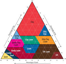
- using this we found that we had soil type Loam.
- we conducted a feel test of the soil by attempting to make a ribbon with the soil but were unsuccessful.


There are 12 Orders of Soil Taxonomy: (1) Gelisols; (2) Histosols; (3) Spodosols; (4) Andisols; (5) Oxisols; (6) Verticols; (7) Aridisols; (8) Ultisols; (9) Mollisols; (10) Alfisols; (11) Inceptisols; (12) Entisols; Click here to learn more!
Ultisols
I choose to elaborate on this soil taxonomy because it is the predominant soil type in the state of Georgia. Ultisols are reddish, clay-rich, acidic soils. They are found in humid temperate or tropical regions. Ultisols are a great support for mixed forest vegetation. They are naturally expedient for forestry and stable materials for construction projects. They occupy just over 8% of the non polar continental land area on Earth.
 |
| Above is a map of the distribution of the Ultisols Soil Taxonomy |
There are 5 suborders of Ultisols: Aquults, Humults, Udults, Ustults, and Xerults. Below is a map of the distribution of the suborder types.
To learn more about Ultisols, click here!
While out at Community Gardens we met Mark Vanderhoek, who is the Director of Media Relations at Mercer University and Founder of Macon Roots. (To learn more about Macon Roots and its impact on the Macon community, click here!)
What we did:
-Did a soil probe with a split spoon corer
-Used a sieve to perform a size fractionation of the soil
-Used a dichotomous key to identify soil types
- using this we found that we had soil type Loam.
- we conducted a feel test of the soil by attempting to make a ribbon with the soil but were unsuccessful.
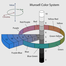
Munsell Soil Color Chart
Soil Texture Diagram

