Wednesday, April 4, 2012


Community Gardens and Soil Analysis

On this lab day, we walked over to the community gardens from school to learn about soil types and take a look at the plants in the garden. The location was on the property of Centenary United Methodist Church.

There are 12 Orders of Soil Taxonomy: (1) Gelisols; (2) Histosols; (3) Spodosols; (4) Andisols; (5) Oxisols; (6) Verticols; (7) Aridisols; (8) Ultisols; (9) Mollisols; (10) Alfisols; (11) Inceptisols; (12) Entisols; Click here to learn more!

Ultisols
I choose to elaborate on this soil taxonomy because it is the predominant soil type in the state of Georgia. Ultisols are reddish, clay-rich, acidic soils. They are found in humid temperate or tropical regions. Ultisols are a great support for mixed forest vegetation. They are naturally expedient for forestry and stable materials for construction projects. They occupy just over 8% of the non polar continental land area on Earth.
Above is a map of the distribution of the Ultisols Soil Taxonomy
There are 5 suborders of Ultisols: Aquults, Humults, Udults, Ustults, and Xerults. Below is a map of the distribution of the suborder types.


To learn more about Ultisols, click here!

While out at Community Gardens we met Mark Vanderhoek, who is the Director of Media Relations at Mercer University and Founder of Macon Roots. (To learn more about Macon Roots and its impact on the Macon community, click here!)

What we did:
-Did a soil probe with a split spoon corer
-Used a sieve to perform a size fractionation of the soil
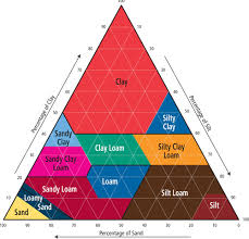
-Used a dichotomous key to identify soil types
          - using this we found that we had soil type Loam.
          - we conducted a feel test of the soil by attempting to make a ribbon with the soil but were unsuccessful.

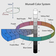
Munsell Soil Color Chart


Soil Texture Diagram


Jackson Springs Park


On this particular lab day, we visited Jackson Springs Park. It is located off of Nottingham Drive in Macon, GA. It is in walking distance to the newly implemented Ocmulgee River Walk.

Here we were able to get hands on experience / learning with some of the different types of rocks. Our professor provided us with pick mattocks to break open the rocks that lined the creek. We mainly saw granite rocks, where we were able to identify hornblende, feldspar, and quartz.

We found a tunnel at one end of the park, which was kind of creepy but cool at the same time. On the rocks near the tunnel we were able to identify bits of mica.

Jackson Springs is a small but rather quaint park! The slow running creek adds a relaxation element which is always enjoyable.


Mystery of the Megafloods

On one of our lab days, we watched an informational filmed called the Mystery of the Megafloods. The film began by defining what a geologist is, stating that it is similar to a detective looking for clues in a crime scene. A geologist looks at the rocks for clues in history.


The primary question that was evaluated in the film was what caused the bizarre landscape in the Montana region (the scad lands). It took us through the thought process of those scientists trying to figure out the cause.Some of the possible causes included gradual erosion caused by rivers and a giant river flooded over and over again. These were later ruled out because of the enormous potholes.
The last ice age was approximately 20,000 years ago. Another hypothesis was that the glaciers melted, causing a great flood. This, too, was soon ruled out because the ice was too remote.
The next hypothesis was that it was been the result of an enormous catastrophe, perhaps a giant flood. This was thrown out too.
The geologists had trouble determining the cause of the bizarre landscape because they were looking at eye view. No one thought to look from a different perspective until aerial photos were shown. The photos revealed giant ripples in the earth, ripples that resembled those in the sand at the beach.


The next hypothesis was that a glacier dammed the lake, forming the ripples. Glacial Lake Missoula formed as the Cordilleran Ice Sheet dammed the Clark Fork River just as it entered Idaho. The rising water behind the glacial dam weakened it until water burst through in a catastrophic flood that raced across Idaho, Oregon, and Washington toward the Pacific Ocean. This was the cause of the bizarre landscape.


For more information on the flooding of Glacial Lake Missoula and how the flooding occurred, click here.

Friday, February 17, 2012

Scoria


Scoria is a type of igneous rock. Igneous rocks are rocks which solidify from molten material (i.e. magma). When magma cools, it can occur in two places - beneath the surface of the earth (plutonic) or on top of the surface (volcanic). Igneous rocks can be identified by the determination of the composition and texture of the rock.

The composition of scoria is mafic and its texture is vesicular. Mafic describes any silicate mineral or rock that is rich in magnesium and iron. The term is actually a portmanteau of the words "magnesium" and "ferric." Most mafic minerals and rocks are dark in color and have a relative density greater than 3. Vesicular texture denotes any volcanic rock characterized by having many cavities (known as vesicles) at its surface and inside. The vesicles form during the extrusion of magma to the surface. At the pressure decreases, magmatic gases are able to come out of the solution, forming gas bubbles in the magma. When the magma is extruded as lava and cools, the lava solidifies around the gas bubbles, preserving them as vesicles.

Interesting fact: The landscaping product commonly called "lava rock" is scoria
Another interesting fact: The cinder mix widely used on outdoor running tracks is made of scoria.

Other rocks that look similar to scoria are slag and pumice.

Sunset Crater in Arizona
Sunset Crater is one of the youngest scoria cones in the contiguous United States. It came about sometime between 1040 and 1100 A.D.


Wednesday, February 8, 2012

An Assortment of Rocks

Amethyst

Amethyst is commonly found in jewelry
Info about Amethyst:

Color: purple / violet
Crystal Habit: 6-sided prism ending in 6-sided pyramid
Crystal System: rhombohedral class 32
Cleavage: none
Fracture: conchoidal
Mohs Scale Hardness: 7
Luster: glossy
Streak: white
Diaphaneity: transparent to translucent
Specific Gravity: 2.65 constant
Melting Point: 1650 degrees Celsius
Solubility: insoluble in common solvents


Feldspar


Info about Feldspar:

Color: pink, white, gray, brown
Crystal System: triclinic or monoclinic
Cleavage: two or three
Fracture: along cleavage planes
Mohn Scale Hardness: 6
Luster: vitreous
Streak: white
Diaphaneity: opaque
Specific Gravity: 2.55-2.76


Galena


Info about Galena:

Color: lead gray and silvery
Crystal Habit: cubes and octahedra, tabular, and sometimes skeletal crystals
Crystal System: hexoctahedral
Cleavage: cubic
Fracture: subconchoidal
Tenacity: brittle
Mohs Scale Hardness: 2.5-2.75
Luster: metallic
Streak: lead gray
Diaphaneity: opaque
Specific Gravity: 7.2-7.6


Quartz


Info about Quartz:

Color: colorless to black, through various colors
Crystal Habit: six-sided prism ending in six-sided pyramid
Crystal System: trigonal trapezohedral, hexagonal
Cleavage: indistinct
Fracture: conchoidal
Tenacity: brittle
Mohs Scale Hardness: 7
Luster: vitreous - waxy to dull when massive
Streak: white
Diaphaneity: transparent to nearly opaque
Specific Gravity: 2.65
Melting Point: 1670 degrees Celsius
Solubility: insoluble at STP


Halite


Info about Halite:

Color: colorless or white; also blue, purple, red, pink, yellow, orange, or gray
Crystal Habit: predominantly cubes
Crystal System: cubic
Cleavage: perfect; three directions cubic
Fracture: conchoidal
Tenacity: brittle
Mohs Scale Hardness: 2-2.5
Luster: vitreous
Streak: white
Diaphaneity: transparent
Specific Gravity: 2.17
Solubility: water soluble


Calcite


Info about Calcite:

Color: colorless or white; also gray, yellow, green
Crystal Habit: crystalline, granular, stalactitic, concretionary, massive, rhombohedral
Crystal System: trigonal hexagonal scalenohedral
Cleavage: perfect on three directions
Fracture: conchoidal
Tenacity: brittle
Mohs Scale Hardness: 3
Luster: vitreous to pearly
Streak: white
Diaphaneity: transparent to translucent
Specific Gravity: 2.71
Solubility: soluble in dilute acids

Wednesday, February 1, 2012

Types of Maps


Isarithmic Map

Isarithmic maps, also known as contour maps, depict smooth continuous phenomena such as rainfall, temperature, or population.


Above is an example of an isarithmic map showing the temperatures across the contiguous United States on August 9, 2000.

Choropleth Map

Choropleth Maps show statistical data aggregated over predefined regions, such as a state or country, using different colors or shadings of the same color.


Above is an example of a choropleth map depicting the estimated median household income across the contiguous United States in the year 2008. The darker shades represent the higher incomes.

Dot Density Map
Dot Density maps use the dot symbol (.) to show the presence of a particular feature or phenomena. They are useful for understanding global distributions of the mapped phenomena and comparing the relative densities of the different regions of the map.


Above is an example of a Dot Density map depicting the United States population distribution in the year 2000. For this particular map, one dot represents 7500 people.

Proportional Symbol Map

A Proportional Symbol map uses symbols of different sizes to represent data associated with the different areas on the map.


Above is an example of a Dot Density map depicting the number of Walmart stores per state in the United States in 2009. The larger the dot the larger the quantity of Walmart stores in that particular state.

My Isarithmic  Map of Annual Precipitation in Georgia


As can be seen with the legend, the darker the shade of blue, the greater the amount of precipitation.

Thursday, January 26, 2012

Cozumel, Mexico!

Went on a Carnival Cruise to Cozumel, where I scuba dived for the first time!
Cozumel is an island in the Caribbean Sea off the eastern coast of Mexico's Yucatan Peninsula. The Yucatan is a karstic terrain. Karst is an area of irregular limestone in which erosion has produced fissures, sinkholes, underground streams, and caverns, all as a result of carbonation-solution. Marine calcareous sediments, also known as limestone (See figures 1 & 2), make up the terrain of the Yucatan peninsula. Moreover, the peninsula is a tectonically stable platform whose current form was created by plates and faults during the early Cenozoic epoch.

Figure 1 - Cozumel Shoreline with limestone
Figure 2 - Tufa limestone

Cozumel Island is the emergent surface of a horst block (a table of land pushed upward between two normal fault lines - see figure 3 below) capped by 122,000 year old Pleistocene limestone.

Figure 3 - Horst block